什麼是全球導航衛星系統? 全球導航衛星系統, 又稱全球導航衛星系統, 代表所有衛星導航系統, 覆蓋全球, 區域和增強衛星導航系統. 例子包括 全球定位系統 在美國, 格洛納斯在俄羅斯, 北斗在中國, 伽利略在歐盟, ETC. 本文將為您帶來GNSS技術全貌.
1. GNSS 是什麼意思?

全球導航衛星系統, 又稱全球導航衛星系統, 代表所有衛星導航系統, 覆蓋全球, 區域和增強衛星導航系統. 例子包括美國的 GPS, 格洛納斯在俄羅斯, 北斗在中國, 伽利略在歐盟, ETC.
換句話說, GNSS是由多個衛星定位系統組成的總稱. 全球定位系統, 這是公眾經常提到的, 是GNSS技術的一種. GPS是目前發展最成熟的衛星定位系統之一,具有應用最廣泛、定位精度最高的特點. 通常, 手機等設備主要透過GPS實現定位.
GNSS 技術用於 定位導航. 更準確地說, 它還有一個不太為大眾所注意的功能, 這就是時機.
全球導航衛星系統 (全球導航衛星系統) 代表以空間為中心的無線電導航和定位系統,提供全天候, 三維座標, 速度快, 向地球表面或近地空間任何地點的使用者提供計時訊息.
2. 如何定義GNSS的工作流程?
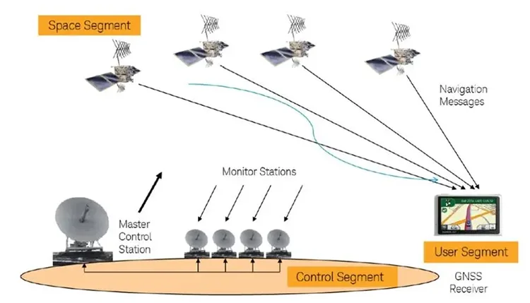
The basic working rules of GNSS are to calculate the range between one satellite with a known location and the user receivers and then integrally analyze the data from several satellites to learn about the exact location of the receiver. To realize the purpose, the location of the satellite is able to be checked out in the satellite ephemeris on the basis of the time recorded by the onboard clocks.
The range from the user to the satellite is acquired by noting down the time that the satellite signals propagate to the users and then multiplying it by the speed of light. (由於大氣電離層的干擾, the distance is not the actual one between the user and the satellite but the pseudo-range (公關), 這意味著如果GPS衛星正常運作, it constantly transfers navigation messages with a pseudo-random code that is comprised of 1 和 0 二進位代碼元素 (簡稱偽代碼).
3. 時間he composition of GNSS
The GNSS technology refers to a measurement technique that is in need of an absolute locating coordinate in a coordinate system in a way of observing GNSS satellites.
The global navigation satellite system is a general term for all navigation and locating satellites, and any system that can fulfill positioning through capturing and tracking its satellite signals can be involved in the scope of the GNSS system.
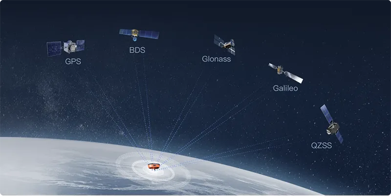
The main components of GNSS are the various global satellite navigation systems. 例如, we are already familiar with the GPS satellite navigation system, as well as China’s Beidou satellite (BDS) navigation system, a national focus. It is crucial to clarify the concept that Beidou and GPS are navigation systems of the same grade and at the same level, without saying who belongs to whom. 反而, both of them take use of the same technical principle to realize the function of navigation and positioning. 更準確地說, they both achieve the function of positioning, velocity and timing (PVT for short).
In addition to the familiar navigation systems mentioned above, the navigation systems available around the globe involve the GLONASS satellite navigation system from Russia as well as the GALILEO satellite navigation system.
Apart from the globally available navigation systems, there are also regional navigation systems that offer services only at a regional scale such as the former Beidou II, 這是, in essence, a regional navigation system, Japan’s Quasi-Zenith System (QZSS), India’s IRNSS system, ETC. Countries like China, the U.S., 俄羅斯, and the European Union, which have a lot of money and consideration of global strategy, are going to develop global navigation systems so they can know where in the world their missiles are flying to. 然而, some countries tend to choose regional navigation systems due to the excessive cost of global navigation systems or technical bottleneck limitations. Take China’s Beidou satellite system as an instance. Although the research and development of the third generation of the Beidou satellite system have almost been completed currently, the first generation, as well as the second generation are also regional systems.
In addition to regional navigation systems, GNSS covers augmentation systems as well. As you can understand from the name, this augmentation system is an aid as well as an enhancement of the systems mentioned above. 換句話說, the existing global system may not satisfy the demands of positioning for some scenarios as well as reliability (mainly aircraft landing). 所以, the augmentation system comes into being. The augmentation systems strengthen our various positioning demands by broadcasting and sending more accurate and richer information. Such augmentation systems embrace the WAAS from the US, the MSAS from Japan, the EGNOS from the EU, the GAGAN from India,
4. GNSS 和 GPS 有什麼差別?
With the traits of all-dimensional, all-weather, all-time and high precision, GPS is a satellite navigation system developed and established by the Department of Defense in the United States. Featuring low-cost, highly precise three-dimensional position, high speed and precise timing, navigation information is offered by the Geographic Positioning System and then send to users around the globe. The Geographic Positioning System remains an application example of satellite communication technologies in the navigation field, which substantially enhances the information-based growth of countries around the globe to inject a strong impetus into the growth of the digital economy.
The full name of GNSS refers to Global Navigation Satellite System which stands for the same term for Beidou system, GPS system, GLONASS system, Galileo system and other single satellite navigation systems. 更重要的是, the Global Navigation Satellite System stands for the augmented systems and the mixture of all these satellite navigation systems and locating systems as well as the enhanced systems. 也就是說, GNSS is a large system comprised of several satellite navigation and locating systems as well as enhanced systems. It refers to a star radio navigation system that utilizes artificial satellites as the navigation station, providing all-weather, high-precision location, velocity and timing information for all kinds of military as well as civilian carriers on the land, sea, air and sky around the world. 所以, it is also considered as a space-focused locating, navigation and timing system.
5. What are the differences between GNSS and the 北斗 satellite locating system?
The full name of GNSS refers to Global Navigation Satellite System which stand for the same term for Beidou system, GPS system, GLONASS system, Galileo system and other single satellite navigation systems. 更重要的是, the Global Navigation Satellite System stands for the augmented systems and the mixture of all these satellite navigation systems and locating systems as well as the enhanced systems. 也就是說, GNSS is a large system comprised of several satellite navigation and locating systems as well as enhanced systems. It refers to a star radio navigation system that utilizes artificial satellites as the navigation station, providing all-weather, high-precision location, velocity and timing information for all kinds of military as well as civilian carriers on the land, sea, air and sky around the world. 所以, it is also considered as a space-focused locating, navigation and timing system.
Established and operated independently by China, 這 Beidou Navigation Satellite System (BDS for short) is a satellite navigation system for the requirements of national security and economic and social development. It is a vital national space infrastructure that offers all-weather, all-day, high-precision locating, navigation and the time service to the users around the globe.
6. GNSS應用實例
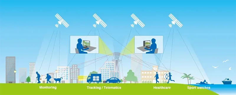
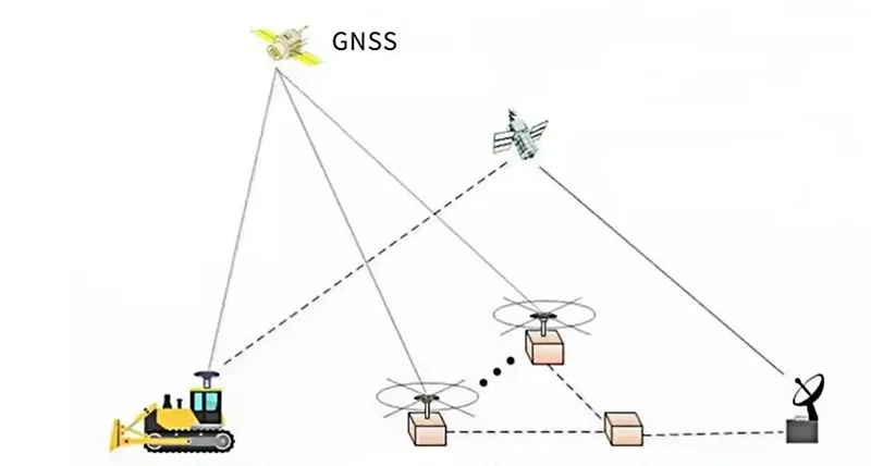
現在, GNSS is able to satisfy the demands of the majority of industrial applications such as transportation, water conservancy, disaster mitigation, maritime, exploration, construction and so on. With the rapid growth of the Internet of Vehicles as well as the significance of 5G for the Internet of Vehicles, GNSS positioning and navigation services is likewise a must for the development of Internet of Vehicles.
Both VG710, the INHAN car wireless communication gateway as well as VT310, the car tracking gateway VT310, integrate GNSS technology to provide precise locating to learn about the vehicle location information, and formed the integrated inertial navigation system. When there is a weak GNSS signal, no signal or multi-path effect, it will result in inaccurate locating. 然而, it still offers excellent locating precision, offering to users constant and precise vehicle locating information to assist users in obtaining real-time vehicle situations. It can also assist users in tracking the location of the vehicle, and ensure the safe and efficient running of the vehicle.
7. GNSS 解決方案
全球導航衛星系統: online monitoring and early warning system solution for high slope
On the basis of the theoretical foundation of the 物聯網, 網際網路, 全球導航衛星系統, as well as with a self-developed monitoring platform and all types of sensors as the core, Slope landslide monitoring takes use of unattended and automated monitoring and takes full advantage of a variety of monitoring means to establish a three-dimensional monitoring network on the surface and the deep part of an underground, carrying out systematic and reliable deformation monitoring of slope landslides.
High-precision locating in automotive intelligence
Automotive intelligence has a high correlation with high-precision positioning technology. With the feature of fast and accurate locating, GNSS provides support to vehicles to precisely judge their current locations within several seconds in order to enhance their overall perception of the environment, thus assisting smart vehicles in making right decisions and accurately directing their actions.
The precise and accruate locating of the variety of intelligent driving scenarios such as unmanned driving, speed limit warning, car lane level navigation, collision warning and autonomous parking cannot be achieved without the support of GNSS high precision locating.
GNSS Solutions Make Indoor Positioning More Accurate & 精確的
Nestware, an IoT geolocation enterprise, is a provider of mixed-signal technologies for IoT modems and DSPs suppliers. 最近, Nestware has announced that by combining its soft-core GPS navigation IP with Synopsys’ IoT communications IP subsystem, a type of GNSS solution with low power consumption is provided. The solution can be integrated into 物聯網 models, thereby lowering the cost of dedicated GNSS chips.
8. 歷史 & 全球導航衛星系統的發展
The world’s first artificial Earth satellite, Sputnik, was launched on October 4, 1957, from the Baikonur launch site in the Soviet Union, which marked the dawn of the human space era.
在 1958, researchers at Johns Hopkins University discovered the Doppler shift of satellite signals and found that the Doppler shift of satellite signals could be utilized to achieve precise locating of the orbit and then turn to utilize the precise satellite orbit to determine the positions of the ground observation points, thus marking the start of the theoretical research of Doppler positioning and the research & development of Doppler satellites and receivers.
在 1964, the U.S. military developed the first generation of Doppler satellite positioning navigation system, 那是, the Meridian Satellite System, which is also called the Navy Navigation Satellite System (NNSS). 同時, the Soviet Union formed the St. Kada (CICADA) Doppler satellite navigation system for ship navigation. 然而, the NNSS and CICADA systems still contain defects such as a small number of satellites, frequent radio signal interruptions, long observation time as well as low precision.
從 1967 到 1974, the U.S. Naval Research Laboratory launched three “Timation” program test satellites to test and implement an atomic clock timing system. In the same period, the U.S. Air Force successfully developed a modern communication mean of pseudo-random noise code (PRN) modulated signal in the “621-B” program.
在 1968, the U.S. Department of Defense established the Navigation Satellite Executive Steering Group (NAVSEG) to develop plans for the next generation of navigation and locating systems.
在 1973, the U.S. Department of Defense integrated the Navy, Army and Air Force to jointly research and develop the second generation of Navigation by Satellite Timing and Ranging of Global Positioning System (NAVSTAR/GPS), which is o the basis of the principle of “time difference ranging navigation”.
The first GPS test satellite was launched in July 1974. The satellite networking was established in 1978 and the construction of the satellite constellation and ground monitoring system was completed. Twenty years have been taken to finish all these three big events with the cost of $30 十億. 更重要的是, All of these have experienced three stages. They are plan demonstration (1974-1978), system construction (1979-1987), and test operation (1988-1993). GPS has become a navigation and positioning system with the traits of all-weather, high-precision and global coverage, and its application has been extended to a variety of fields including military, public life and scientific research.
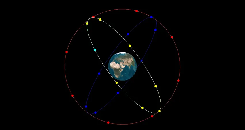
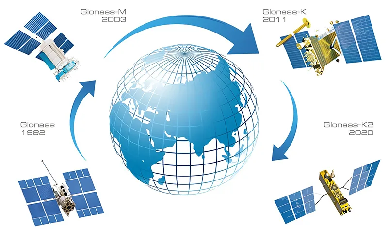
The Soviet Union initiated the construction of the Global Navigation Satellite System (格洛納斯) 在 1982, 哪個, 然而, was delayed because of the collapse of the Soviet Union. Then the system was completed by Russia in 1996 with further investment, making it become another navigation and positioning system that was based on time difference ranging. China’s Beidou Navigation Satellite System (BDS) has been started to be tested and demonstrated since 1983, and the construction of the “Beidou Generation” system was completed between 2000 和 2003. This system is active real-time navigation and positioning system that is focused on regions, which is unique in that it has the functions of both navigation and locating and short message communication at the same time. Although its coverage area and locating precision are not as wide and good as GPS, it is a simple system with low investment and a short cycle, which satisfies the urgent demands of China’s national defense and construction at that time. The “Beidou-2” system, which started in 2007, carries the same functions as that of GPS. The system is a navigation and positioning system on the basis of time difference ranging, covering and servicing the entire Asia-Pacific region in 2012. It is planned to finish the global network coverage (Beidou III) and offer global high-precision navigation and positioning services in 2020. 更重要的是, the Beidou system inherits the special benefit of offering short message services.
The Galileo Navigation Satellite System (GNS) developed by the European Union is also a high-precision navigation and positioning system on the basis of the principle of “time difference ranging navigation”. Since the system program has begun to be demonstrated in 1994 and launched in 2002, the system has already been equipped with the initial operational capability until the end of 2016 after several delays. All satellites are scheduled to be launched in 2020.
更重要的是, the Quasi-Zenith Satellite System (QZSS) developed by Japan as well as the Regional Navigation Satellite System (IRNSS) developed by India is under construction. In order to strengthen the growth and cooperation in the field of global satellite navigation, especially to offer high-precision navigation and locating services and to provide support for geodetic and geodynamic research, the International GPS Service (IGS) was set up by the International Association of Geodesy (IAG) 在 1993. Then the organization started to operate on January 1st, 1994. With the emergence of other navigation systems around the globe, the organization changed its name to International GNSS Service (IGS) 在 1999 but it is still referred to as IGS.


NB-IoT Applications, Solutions and Use Cases")