北斗衛星導航系統 (北斗系統簡稱) 是我國為滿足國家安全和經濟社會發展需求而獨立建造、運作的全球衛星導航系統. 它還充當重要的國家時空基礎設施,提供全天候, 整天, 高精度定位, 為全球用戶提供導航和授時服務.
本文帶您全面了解北斗衛星導航系統.

北斗衛星導航系統是指中國研究發明的世界性衛星導航系統. 這也是繼中國衛星導航系統誕生後第三個成熟的衛星導航系統 全球定位系統 以及格洛納斯. 北斗衛星導航系統, 來自美國的全球定位系統, 俄羅斯GLONASS、歐盟GALILEO均為聯合國衛星導航認可的合格供應商.
一般來說, 導航系統包含基本功能的集合, 包括“定位”, 「目的地選擇」, “路線計算”和“路線引導”. 更重要的是, 該系統在其更高性能係列中支援彩色圖顯示. 所有這些功能都需要道路網絡的數位地圖, 通常儲存在 CDROM 上.

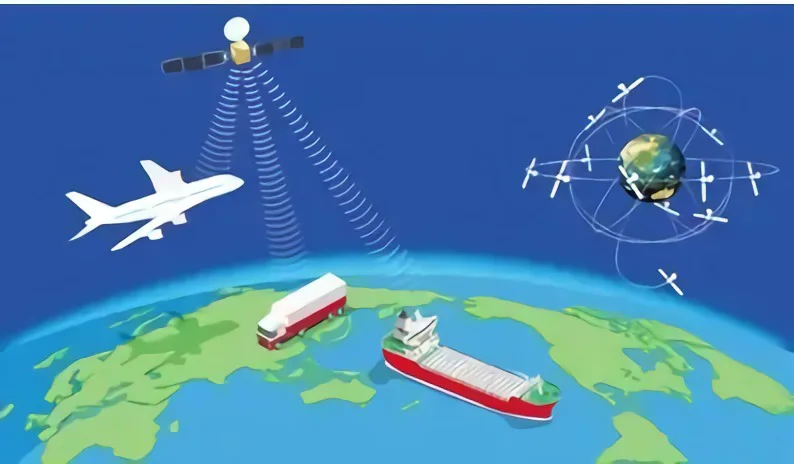
北斗衛星導航系統由覆蓋太空的3個部分組成, 地面和用戶. 太空部分由一定數量的地球靜止衛星組成, 傾斜地球同步軌道衛星與中圓地球軌道衛星. 地面部分覆蓋了包括主控站在內的許多地面站, 時間同步 & 注射站和監測站, 以及衛星間連結操作和管理設施. 用戶部分由晶片等基本部件組成, 相容於其他衛星導航系統的北斗系統模組和天線, 和終端項目, 應用系統和應用服務.
現在, 北斗系統運作平穩, 北斗系統服務性能已在全球範圍內進行評估測試. 性能覆蓋全球定位精度優於十米等領域, 測速精度優於 0.2 公尺每秒, 計時精度優於 20 奈秒以及服務可用性優於 99%. 亞太地區表現更提升.
3. 北斗一號簡介, 北斗-2 以及北斗三號

北斗衛星導航系統
中國自主建設的導航定位通訊系統, 北斗衛星導航系統是第一代具有溯源功能的區域性三維衛星系統. 該系統由以下部分組成 23 地球同步衛星, 1個中央控制站, 多個目標校準站和大量用戶單位. 融合了傳統天文導航定位和地面無線電導航定位的優點, 該系統創建了一個相當於太空中建立的無線電導航站.
系統可完成雙向訊息通信, 通訊資料主要由兩類組成: 漢字及編碼. 能夠識別地理緯度, 為使用者提供隨時隨地的經度和海拔高度, 主要提供導航, 定位, as well as timing for public security, highway traffic, railroad transportation and marine operations in the territory, territorial waters and neighboring areas of China. 更重要的是, short message communication services are also provided among users and between users and the central control station.
The BeiDou-2 Navigation Locating Satellite System
The BeiDou-2 Navigation Locating satellite System(BD2 or BeiDou-2) is a global satellite navigation system independently researched and developed by China. The BeiDou-2 is not a simply extended version of the BeiDou-1. 反而, it has been an optimized version based on the drawbacks of the BeiDou-1, offering global navigation locating services for all-rounded areas including the land, 海洋和空氣. 具有與美國GPS、歐盟伽利略衛星導航系統類似的功能. 在四月 30, 2012, 中國在西昌衛星發射中心成功發射“一箭兩星”. 長徵三號乙運載火箭將北斗第十二、十三顆衛星成功送入預定轉移軌道.
第三代北斗導航定位 Satellite System
北斗三號全球衛星導航系統 (簡稱北斗三號系統) 由24顆中圓形地球軌道衛星組成, 三顆地球靜止軌道衛星與三顆傾斜地球同步軌道衛星, 總共 30 衛星.
北斗三號衛星導航系統支援2種服務, 這就是所謂的開放服務與授權服務. 開通的服務功能為支援免費定位, 服務領域的測速和授時,定位精度可達十米, 計時精度 50 奈秒和速度測量精度 0.2 公尺每秒. 授權服務透過提供更安全的定位來發揮作用, 速度檢測, 向授權使用者提供時間和通訊服務以及系統整合訊息.
4. 時間北斗系統應用案例

智慧駕駛
採用5G+北斗高精度定位系統, 使用者無需建立自己的基本校準站. 用戶只需一個帳號或一個SDK即可獲得全國高精度定位服務.
車規級MU plus 全球導航衛星系統 配備緊密耦合求解演算法,確保車輛在隧道、城市峽谷等複雜環境下的持續定位. 5利用G網路高頻寬、低時延技術,實現車載設備定位終端與高精度定位網路的差分資料交互,確保高精度位置資料安全.
智慧港航
最近幾年, 中國航運業實現快速成長,但勞動成本持續飆升,營運安全仍需提高.
The BeiDou system with 5G plus technology is able to support all-rounded as well as all-weather dynamic and static locating services in a precise and accurate manner for port and navigation scenarios such as port machines, collector trucks, personnel, beacons, ships and locks to enhance the operational efficiency, safety level and service quality of port and navigation infrastructure. High-precision locating systems are installed in various types of harbor and navigation production links, which can reasonably monitor and control collision risks and deviation risks. 5G networks can be rented in order to realize real-time contacts and connections between the remote center and the port and maritime operation sites, guaranteeing the timeliness and precision of equipment message transmission.
Smart Logistics
Inspection robots, logistics vehicles, cloud AGVs, high-definition video cameras and other equipment in the logistics operation process can be connected to the 5G private networks to achieve centimeter-level accurate and precise locating with the help of China Mobile’s 5G networks, the BeiDou high-precision locating system as well as a space-time information platform.
2.6G-band 5G base stations are able to ensure end-to-end service latency and achieve multi-slice bearing logistics business for logistics-specific business scenarios to guarantee the security, 隱私, high speed and reliability of the proprietary monitoring network. An intelligent logistics platform is set up with multiple accesses, end-to-edge cloud collaboration, video networking, and edge artificial intelligence with the help of big data analysis and cloud services.
Smart Bus
Installed with terminals like intelligent driving controllers, BeiDou high-precision locating on the bus, accurate and precise vehicle location information can be acquired to develop in-depth guidance strategies in order to support functions such as vehicle energy-saving and safe passage in and out of stations and crosswalks. Multi-fusion sensors such as radar and cameras are deployed at road junctions to realize real-time fusion sensing and information dissemination of road events.
Bike Sharing
現在, ordinary satellite locating is mostly utilized in bike sharing. 然而, the locating system features poor locating precision and stability, which leads to poor user experience in finding and returning bicycles, 企業維運調試效率低,部門監管難度高.
高精度定位服務可將自行車定位精度提升至亞米級,並支援電子圍欄等功能, 軌跡追蹤與安全預警. 更重要的是, 提供以時間池為基礎的計費方式,實現大批量單車統一計費,提供使用者便利的體驗.
精確的 & 精準導航
北斗高精度定位系統已廣泛應用於大眾消費領域, 共享經濟與民生. 他們之中, 智慧型手機的定位精度在十公尺左右. 更重要的是, 有跳躍點和偏移量, 無法滿足車道級地圖導航和精準叫車需求.

這些技術主要包括即時運動學, 精確點定位, 被協助者 北斗系統, 北斗地基增強系統與北斗星基增強系統.
即時運動學
即時動態定位, 或即時運動學, 有以下工作原理: 基本校準站和移動站的接收器不斷監測衛星的移動. 基礎標定站將即時運動測量值傳送至移動站接收機,移動站同時實現觀測到的可見衛星訊號的接收. Then the basic calibration station will compare its own real-time kinematic measurement value with the received kinematic measurement value in real time to handle the data to calculate its own coordinates of the space so as to fulfill its own highly precise locating. The differences in the locating precision between the two kinematic measurement values can reach the centimeter level.
Precise Point Locating Technology
The Precise Point Locating Technology was first proposed by the U.S. Jet Propulsion Laboratory(JPL) Zumberge in 1997. The proposal as well as the realization of the technology have laid a foundation for the growth of the Difference Augmented Technology of the Commercial Global Satellite Station that is on the basis of the real-time Precise Point Locating Technology. 融合了GNSS標準單點定位和相對定位的優點, 精密單點定位技術已發展成為一種新型GNSS高精度定位方法.
輔助北斗快速定位技術
北斗系統, 也稱為輔助北斗定位技術, 能夠增強北斗衛星定位系統的性能. 借助行動通訊運營基地台, 北斗輔助定位技術能夠快速定位物體. 北斗輔助定位技術的基本工作原理是在衛星訊號接收效果良好的位置設置多個參考衛星定位接收機。. 透過北斗輔助定位系統伺服器與終端的交互, 可以獲得端子的粗略位置。然後將本終端所需的星曆、時鐘等輔助資料透過行動網路傳送給終端, 終端進行北斗系統定位測量。北斗輔助定位技術具有定位時間短等獨特優勢, 低功耗、高靈敏度.
北斗地基增強系統
北斗地基增強系統旨在建立以北斗系統為主、相容於其他衛星導航系統的高精度衛星導航服務體系. 配合北斗或GNSS高精度接收機使用, 增強服務區域1-2m即時高精度導航定位服務, 透過地面參考站網路和衛星廣播手段實現分米和厘米級, 行動通訊, 數位廣播.
北斗星基增強系統
北斗星基增強系統仍然是北斗衛星導航的重要組成部分. 在靜止衛星上配備衛星導航增強訊號轉發器, 它可以廣播星曆錯誤, 衛星時鐘差異, 提供用戶電離層延遲等修正訊息,實現原有衛星導航系統定位精度的提高. The combination of the satellite-based augmentation system and the ground-based augmentation system are able to create a more efficient satellite navigation high-precision locating service network and set up a high-precision location service infrastructure environment for professional applications such as territorial mapping, marine survey, precision agriculture, disaster monitoring, unmanned aerial vehicles and unmanned vehicles, as well as popular applications such as car navigation.

Global Navigation Satellite System is a general term, which is included with the four navigation satellite systems covering Global Locating System, the GLONASS system, the GALILEO navigation system and the BeiDou system. 更重要的是, it also involves the MSAS system from Japan, GAGAN from India and NIG-GOMSAT-1 from Nigeria.
所以, GNSS functions as a star-rated radio navigation system utilizing the artificial satellite as the navigation station to provide all-weather, highly precise locations, speed and timing information for all kinds of military and civilian carriers on the land, sea, air and sky around the globe, which is also referred to as space-oriented locating, navigation and timing systems.
The most important feature of the “BeiDou” system lies in the close connection with navigation and communication, which is not available in other navigation systems. 例如, the BeiDou system can play a crucial role in places such as deserts and grasslands, where cell phones cannot be utilized.
The BeiDou-3 system utilizes a triple-frequency signal, which is able to better eliminate the impact of the ionosphere, improve locating reliability, and enhance data pre-processing capabilities, thus greatly boosting the efficiency of fuzziness fixation.
The locating precision of the BeiDou system will be boosted to the level of 2.5 meters to 5 米. Also with the initial service supported by the BeiDou ground-based augmentation system, it is able to support services at the meter, sub-meter, decimeter, and even centimeter levels.
7. GPS和北斗衛星定位系統有什麼差別?

The most eye-catching difference between GPS and the BeiDou satellite locating system is that GPS has not been equipped with the function of sending and receiving short text communication while the BeiDou satellite locating system supports the function of sending and receiving short text communication. 然而, it is vital to note that cell phones generally cannot support the function of sending and gathering texts of the BeiDou satellite locating system for the reason that the locating chip on the cell phones can only support obtaining locating information from satellites.
GPS 利用雙頻訊號. 然而, the BeiDou satellite locating system takes use of a triple-frequency signal. 理論上來說, GPS has comparable locating precision globally while the locating precision of the BeiDou satellite system is specially strengthened for China and its surrounding areas.
GPS has actually been equipped with 32 衛星. The more satellites there are, the more redundant data will be obtained, the more reliable the data will be, and the smaller the DOP value will be. Right now, the BeiDou satellite locating system has been only equipped with sixteen satellites. 衛星數量將會越多, 獲得的觀測數據越多, 越不可避免精度就會提高.
GPS是單向的, 這意味著接收器只能收集位置訊號,只能知道你在哪裡. 相反, 北斗衛星定位系統是雙向的, 意味著系統能夠將你的位置傳送給你的朋友,讓你的朋友知道你在哪裡,同時也接收訊號. 一般來說, GPS和北斗衛星定位系統都具有導航定位功能,但定位技術不同,定位範圍不同。. 北斗導航系統預計將具備全球定位導航功能 2020. 然而, GPS is an all-weather locating system that covers areas around the world.
China has begun to conduct research on the technologies and plans of satellite navigation systems since 1970.
The engineering set-up of the BeiDou satellite navigation system was initiated in 1994.
Two Earth Static Orbital Satellites were launched and the relevant systems are set up to come into use in 2000. The functions like timing, and information transmission of China’s systems have been changed from the original Global Positioning System to the BeiDou satellite navigation system.
The engineering construction of the BeiDou-2 navigation system was launched in 2004.
By the end of 2012, fourteen satellites (including five geostationary orbit satellites, 五顆傾斜地球同步軌道衛星與四顆中圓地球軌道衛星) 推出以形成相關網絡. 在與北斗一號系統技術體系相容的基礎上, 北斗二號系統增加被動定位系統,提供定位, 速度測量, 為亞太地區用戶提供授時和簡訊通訊服務.
北斗三號導航系統工程建設啟動 2009.
在 2018, 我國北斗三號網路全面完成.
六月 23, 2020, 中國成功發射北斗系統第五十五顆導航衛星, 標誌著北斗三號全球衛星導航系統星座全面建設部署.


