With the features of all-weather as well as space-focused, Global Positioning System(GPS) refers to a kind of navigation system which is able to satisfy the requirements of the demands of continuous and precise determination as well as locating of three-dimensional positions and three-dimensional movement and time for military users located anywhere around the globe or in near-Earth space. With the features of medium-range and circular, it is an orbit satellite navigation system.
The article will introduce to you the definition of the Global Locating System and its application environments.
1. How to define Global Positioning System?

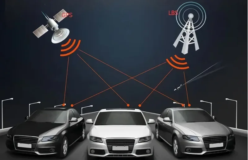
GPS is the short term for Global Positioning System (GPS), and its Chinese short term is “Ball system”. Being a new generation of space satellite navigation and locating systems, Global Positioning System is jointly invented by the Army, Navy and Air Force departments of the U.S. in the 1970s. The functions of GPS have to be included with three elements: GPS terminals, transmission network connections and monitoring platforms. These three kinds of components are indispensable. With the 3 components, the system is able to offer services such as anti-theft of vehicles, robbery resistance, the monitoring of driving routes as well as the command of calls.
2. The Working Principles of GPS
The basic working principles of the GPS navigation system refer to the measurement of the distance between the satellites with a known position and a user receiver, and then integrally analyzing the data gathered from multiple satellites to learn about the exact positions of the receivers. In order to realize the intention, the location of the satellite can be checked out in a satellite ephemeris on the basis of the times gathered by the onboard clocks. The distance from the users to the satellite is acquired by recording the time that the satellite signal propagates to the users and multiplies it by the speed of light (Owe to the interference of the ionosphere of the atmosphere, the distance is not the actual one between a user and a satellite but the pseudo-range (PR), which means that if the GPS satellite works normally, it will constantly transfer navigation messages with a pseudo-random code that is composed of 1 and 0 binary code elements (pseudo-code for short).
3. The composition of the Global Locating System
The part of space
GPS satellite
With a cylindrical body as well as solar sails on both sides, the GPS satellites are able to automatically orient to the sun. Every satellite is equipped with multiple atomic clocks, offering high-precision time standards to the satellites. With fuels and spraying nozzles on board, the satellites are able to regulate their orbits under the control of the ground control systems.
The basic functions of GPS satellites involve:
- Receive and store navigation messages from the ground control systems and then the messages are modulated on the carrier wave to broadcast to the users.
- Adjust the orbits and the satellite clocks, repair faults or activate spare parts to maintain the normal operation of the entire system on the basis of the commands of the ground control systems.
GPS satellites can be categorized into two types: test-type satellites and working satellites.
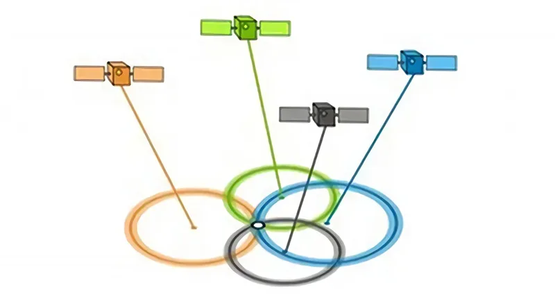
Satellite Constellation
The collection of GPS satellites that can be launched into orbit and work properly is named the GPS satellite constellation. The total number of satellites that is currently in operation is 24, which are scattered over six orbital planes, with four satellites in every orbital plane, ensuring that users at any position can observe four to eight satellites at any time. In order to replace the malfunctioning satellites in a timely manner, three additional satellites that have been launched into orbit and are working properly have been issued as backup satellites, and the 24 plus 3 constellations are viewed as the basic constellations.
The part of ground monitoring
The ground facilities which can provide support for the proper operation of the entire system are referred to as the ground controlling parts, which are comprised of the master control station, the monitoring station, the injection station as well as communication and support systems.
Main control station
The master control station functions as the administrative and technical center of the entire ground monitoring system, which is playing the main role of managing and coordinating the operation of all parts of the ground monitoring system.
Based on the materials sent by every monitoring station, the satellite orbit, as well as the satellite clock correction number, will be calculated and predicted, and then a navigation message in the prescribed format will be compiled and transferred to the ground injection station.
The satellite orbit and the satellite clock readings will be adjusted. When the satellite fails, the system is in charge of repairing or activating the spare parts to keep their normal operation. And if the satellite cannot be repaired, the spare satellite is invoked to replace it to maintain the reliable operation of the entire system.
Monitoring Station
The monitoring station functions as an unattended automatic data collection center. Its main functions cover
- The pseudo-range measurement of every GPS satellite in the field of view,
- The automated measurement and recording of meteorological elements such as temperature, barometric pressure and relative humidity with the help of meteorological sensors.
- The correction of pseudo-range observations is followed by edits, smoothing and compression, and then transfer to the master control station.
Injection Station
The injection station functions as a ground facility that inputs navigation messages and other commands to GPS satellites. It can store the received navigation messages in a microcomputer and then inject these navigation messages and other commands into the satellite respectively with a large-aperture transmitting antenna when the satellite passes over it.
Communication and support system
The communication and auxiliary systems are the agencies and facilities in the ground surveillance system that are in charge of data transformation and the provision of other auxiliary services. The communication system of GPS is a mixture of terrestrial communication lines, submarine cables and satellite communication.
The user parts are mainly composed of the users and devices like GPS receivers.
GPS Receiver
The instrument and equipment that are able to gather, process and measure GPS satellite signals for navigation, locating, orbiting and timing are referred to as GPS receivers. GPS receiver is comprised of receiving antenna with preamplifiers, signal processing equipment, input and output equipment, power supply as well as microprocessors and other components.
Antenna Unit
With the composition of an antenna and a preamplifier, the Antenna unit carries a receiving antenna that functions as a device that can convert the energy in the electromagnetic wave signal emitted by the satellite into an electric current. Due to the extremely weak satellite signals, the current generated is always necessary to be amplified by the preamplifier before coming into the GPS receiver.
Receiving Unit
The components of receiving units contain receiving channels, storage equipment, microprocessors, input & output devices and a power supply.
Being a component of the receivers, the receiving channel is applied to track, process, and measure the satellite signals. The channel is comprised of wireless radio components, digital circuitry and other hardware and specialized software, which is referred to as channels for short. A channel can only track one signal of a certain frequency in a satellite at a certain time. Being the vital functions of the receiver channels, the pseudo-range measurement acquires the satellite navigation messages and rebuilds the carrier waves for the measurement of carrier phases.
4. What are the types of Global Locating Systems?
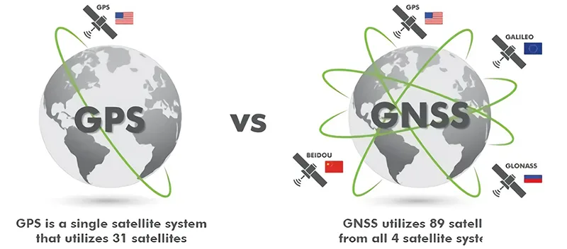
The four great satellite navigation systems are divided into Global Positioning System in the United States, the GLOBAL NAVIGATION SATELLITE SYSTEM developed by Russia, Galileo Satellite Navigation System from Europe and the Beidou satellite navigation system in China.
1. Global Positioning System in the United States
GPS refers to a new generation of satellite navigation and locating system with all-rounded and three-dimensional navigation and locating functions in real time at sea, on land and in the air, which was researched and developed by the United States in the 1970s and was fully finished in 1994 with 20 years of development time and the cost of $20 billion.
The utilization of China’s mapping and other departments in the past ten years has suggested that GPS has been warmly welcomed by the majority of mapping workers with the features of all-weather, high-precision, automated and high-efficiency. What’s more, the system has been victoriously utilized in geodesy, engineering surveying, aerial photogrammetry, navigation and control of carriers, the monitoring of crustal motion, the monitoring of engineering deformation, resources discovery, geodynamics and more disciplines, thus bringing an overwhelming technical revolution to the industry of mapping.
2. “GLONASS” system developed by Russia
GLOBAL NAVIGATION SATELLITE SYSTEM was first developed during the Soviet era, and the program was continuously developed by Russia. After gaining independence, Russia started to develop its GNSS technology in 1993.
The system started to be operated in 2007. At that time, it could only be utilized for satellite locating and navigation services only within Russia. By 2009, the service range of the system was extended to the entire world. The major services of the system cover the identification of coordinates and information, as well as the speed of movement of land, sea and air targets.
3. Galileo Satellite Navigation System from Europe
Galileo’s satellite navigation system refers to the global satellite navigation and locating system developed and set up by the European Union. The program was announced by the European Commission in February 1999, and jointly being in charge of by the European Commission and the ESA. The system is comprised of thirty satellites with an orbital altitude of 23,616 kilometers with the components of 27 working satellites and three backup satellites. The satellite orbits are at an altitude of around 24,000 KM and are situated in the 3 planes of the orbits carrying an inclination of 56 degrees.
5. The application cases of the Global Locating System
The application of GPS has been very extensive. For example, GPS signals can be applied to navigate we can at the sea, and in the air. Also, it can be applicable for missile guidance, the precise locating of geodesy and engineering measurement, time transfer and speed measurement, etc. In terms of the field of mapping, GPS satellite positioning technology has been utilized to establish a high-precision national geodetic control network with the purpose of determining the global dynamic parameters of the earth. What’s more, the technology has been applied to set up a land and ocean geodetic datum to carry out high-precision island and land joint surveys and ocean mapping. Also, it is to monitor the state of the earth’s plate movement and crustal deformation and is applicable for engineering measurement. It has been developed as the major way to set up urban and engineering control networks.
GPS is utilized to locate and measure the camera positions at the moment of aerospace photography, enabling rapid mapping of aerial surveys with only a little or no ground controls, thus leading to a technological revolution in GIS as well as global environmental remote sensing monitoring.
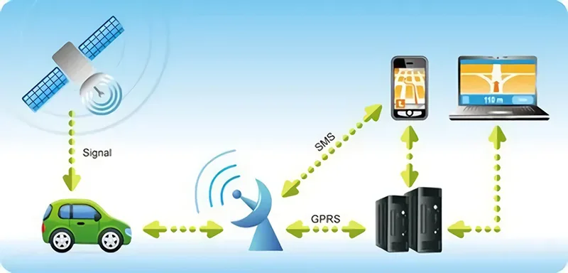
A lot of commercial and governmental institutions also make use of GPS devices to track the position of their vehicles, which generally requires the assistance of wireless communication technology. Several GPS receivers integrate radios, wireless phones and mobile data terminals to adapt to fleet management requirements.
Systemic technology is primarily providing locating navigation for moving objects like boats, ships, cars, planes and so on. Cases like:
- The ocean navigation of vessels and inbound pilotage.
- Aircraft route guidance and landing.
- Autonomous vehicle navigation.
- The Ground tracking of vehicles and city smart traffic management.
- Lifesaving when emergencies occur.
- Individual travel and wild adventure.
- Personal communication terminals (integrated with PDA, electronic map, etc.).
- Time synchronization for power, post and telecommunications networks
- The access to accurate time.
- The access of accurate frequency.
- Geodetic survey and control survey of all types of grades.
- The release of roads and a variety of lines.
- Topographic surveys under the water.
- The measurement of crustal deformations, the deformation monitoring of dam and large constructions.
- GIS applications.
- The control of construction machinery (tire cranes, bulldozers, etc.).
- Precision and fine agriculture.
- Vehicle GPS positioning management system is primarily comprised of vehicle GPS autonomous locating, with the combination of wireless communication systems for vehicle scheduling management and tracking.
6. The solutions for Global Locating System
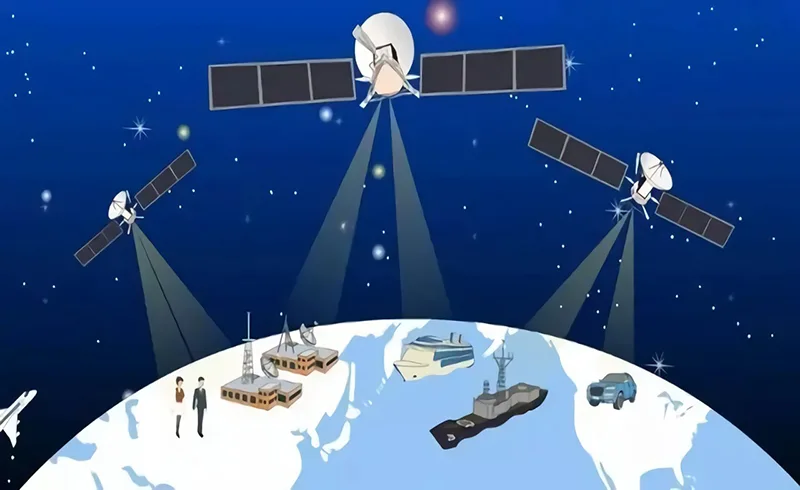
With the growth of the times and the development of society, locating systems has been an indispensable part of our lives. The locating system functions as a collection or a device that is interrelated with the aim of determining space locations. It is primarily applicable for vehicle navigation, emergency response, missile production and guidance, aviation rescue and manned spacecraft protection detection.
Satellite Locating System
The satellite locating system refers to a satellite system with the coverage of the accumulation of twenty-four satellites. This system ensures the realization of navigation, positioning and other functions with the features of high precision, automated measurement, three-dimensional fixed speed and timing, fast and time-saving, high efficiency, wide application, as well as multiple functionalities. Also, the system is integrated into a variety of case industries of the construction of the national economy, the construction of national defense and social growth. The fields cover atmospheric physical observation, geophysical resource exploration, engineering measurement, deformation monitoring, and urban planning, which mainly offers locating systems for ships, cars, aircraft and other moving objects. At the same time, the locating system utilizes the radio locating system used by the satellite for achieving an active locating model.
Global Positioning System
The Global Positioning System carries an atomic clock with great stability and then is synchronized with the ground clock. Due to the constant speed of radio waves, the time delay between a GPS signal transmitter and a receiver is proportional to the time of flight using the navigation equation. The Global Positioning System is comprised of a spatial component, a control component and a user component.
Based on GPS standards, the action of mobilizing satellites is not precise and accurate. After a satellite is mobilized, engineers track the new orbit from the ground, and then upload the new ephemeris and mark the satellite available again. The information assurance is significantly enhanced compared to the current Operational Control System (OCS).
Security Guard Locating System
The location information is collected based on the demand of key location monitoring, and the real-time position information of the security guards that are on duty can be queried more precisely. Property management engineers, security personnel, and management personnel need to contact each other inside buildings. The ways to contact include the intercom, fixed-line telephones, cell phones, and radio search (inside the mall), which are the traditional and older means. Problems will occur such as the distance limitations of intercoms, high-power radiation and interference, the inconvenience of fixed-line telephones, unstable signal and high cost of cell phones, the interference to the guests when using radio search and so on.
7. How does the precision of the Global Positioning System look like?
Global Positioning System features highly precise, all-weather, highly efficient, multiple functions, easily operated, widely applied and so on. The application practice has proved that the relative locating precision of the Global Positioning System is able to reach 10-6 meters within 50KM, 10-7m from 100-500KM, and 10-9m from 1000KM. In the precision locating of the range from 300 to 1500M project, the plane of its plane position error is less than 1mm for more than one hour of observation. Compared to the length of the edge measured by the ME-5000 electromagnetic wave rangefinder, the biggest difference in the length of the edge is 0.5mm, and the calibration error is 0.3mm.
8. What are the differences between GNSS and GPS?
With the traits of all-dimensional, all-weather, all-time and high precision, GPS is a satellite navigation system developed and established by the Department of Defense in the United States. Featuring low-cost, highly precise three-dimensional position, high speed and precise timing, navigation information is offered by the Geographic Positioning System and then send to users around the globe. The Geographic Positioning System remains an application example of satellite communication technologies in the navigation field, which substantially enhances the information-based development of countries around the globe to inject a strong impetus to the growth of the digital economy.
The full name of GNSS refers to Global Navigation Satellite System which is the same term for BeiDou system, GPS, GLONASS system, Galileo system and other single satellite navigation systems. What’s more, the Global Navigation Satellite System stands for the augmented systems and the mixture of all these satellite navigation systems and locating systems as well as the enhanced systems. That is to say, GNSS is a large system comprised of a few satellite navigation and locating systems as well as enhanced systems. It is a star radio navigation system that utilizes artificial satellites as the navigation station, offering all-weather, highly precise location, velocity and timing messages for a variety of military and civilian carriers on the land, sea, air and sky around the globe. Therefore, it is also considered a space-focused locating, navigation and timing system.
9. What are the differences between GPS and the Beidou satellite locating system?
The most eye-catching difference between GPS and the Beidou satellite locating system is that GPS has not been equipped with the function of sending and receiving short text communication while the Beidou satellite locating system supports the function of sending and receiving short text communication. However, it is vital to note that cell phones generally cannot support the function of sending and gathering texts of the Beidou satellite locating system for the reason that the locating chip on the cell phones can only support obtaining locating information from satellites.
GPS utilizes a dual-frequency signal. However, the Beidou satellite locating system makes use of a triple-frequency signal. Theoretically speaking, GPS has comparable locating precision globally while the locating precision of the Beidou satellite system is specially strengthened for China and its surrounding areas.
GPS has been equipped with 32 satellites. The more satellites there are, the more redundant data will be obtained, the more reliable the data will be, and the smaller the DOP value will be. Right now, the Beidou satellite locating system has been only equipped with sixteen satellites. The more satellites will be, the more observation data will be acquired, and the more evitable the precision will be enhanced.
GPS is one-way oriented, which means that the receiver can only gather the location signals and only know where you are. On the contrary, the Beidou satellite locating system is two-way oriented, meaning that the system is able to transfer your position to your friends to let your friends know where you are while also receiving signals. In general, GPS and the Beidou satellite locating system both function as navigation and locating systems but they make use of distinctive locating technologies and therefore have different locating ranges. The Beidou navigation system is expected to be equipped with global locating and navigation functions by 2020. However, GPS is an all-weather locating system that covers areas around the world.
10. The History as well as Development of the Global Positioning System
The predecessor of GPS was a meridian satellite locating system researched and developed by the U.S. Army in 1958. The system worked with a network of five to six satellites that circled the Earth up to 13 times per day. However, it could not provide altitude information and was not as accurate as it could be in terms of locating precision.
GPS originated from a U.S. military project that started in 1958 and was put into use in 1964. The U.S. Army, Navy and Air Force departments jointly invented a new generation of the satellite locating system, also named the Global Positioning System in the 1970s.
The major intention of the design of GPS is to provide real-time, all-weather worldwide navigation services for the 3 main areas including the land, sea and air. It is utilized for some military intentions such as INTEL collection, the monitoring of nuclear explosions and emergency communications. With more than twenty years of research and experiments as well as with the cost of $30 billion, a constellation of 24 GPS satellites had been laid out by 1994, with global coverage of 98%. Global Positioning System carries another definition in the mechanical field, that is, Geometrical Product Specifications – GPS for short.


: The Definitive Guide 2022")


