Geofencing is similar to LBS, although there is a bit of difference. It takes a central point in a particular area and covers the adjacent radius of 3 or 5 kilometers. Geo-fencing concentrates more on describing regional boundaries than a specific point to establish the circle centre and outer equidistant. It outlines the actual shape, range, and area of precise coordinates like office blocks and residential areas. This article will discuss geo-fencing and help you understand what this technology entails.
What is Geo-Fencing Technology?
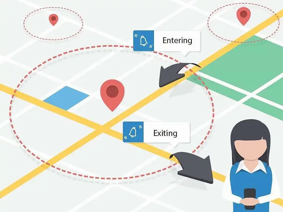
Geo-fencing is a new LBS application that creates a virtual geographical boundary using a virtual fence. When a phone enters, leaves, or moves within a particular geographic region, it can use geofencing technology to receive warnings and notifications automatically.
With geo-fencing technology, users can now use location-based social networking sites to sign in automatically once they enter an area. Although slightly different from LBS, geo-fencing is still a type of LBS. It takes a particular region as the centre and covers the adjacent radius of 3 or 5 kilometers.
Geo-fencing mainly emphasizes the explanation of area boundary, rather than using a particular point as the circle centre and outer equidistant. It precisely frameworks the actual shape, range, and area of specific coordinates like office blocks and residential areas.
How does Geo-Fencing Work?

As a location-based marketing strategy, geo-fencing technology uses GPS signals to establish when prospective customers get into a border. Businesses set boundaries nearly anywhere when they want to trace potential customers around their physical locality.
Geo-fencing is an exceedingly intricate strategy of marketing that permits businesses to target customers as per their location about that business. Frequently, companies geo-fence near certain businesses, conferences, or even events. It solely relies on the main targets of the company. For instance, if a business has new sales and wants to notice a target client, it can send automatic text messages to potential customers whenever they enter the geo-fencing zone.
Moreover, you can use geofencing around an event and SMS, ads, or push notifications to target individuals whenever a certain event in your target market entices prospective customers.
Technologies Used in Geo-Fencing Marketing

With the rapid growth of smart terminals, geo-fencing technology can appear in the vision of people based on intelligent terminals. As an application of a location-based service, geo-fencing applies a virtual fence to them on a virtual geographical border. A notification or alarm message is shown via the application whenever a terminal gets into the virtual geographical boundary.
Due to the perception and model of collecting information services, geo-fencing technology has primarily been employed in sectors like smart homes, personal assistants, shopping, and personal location.
Geo-fencing based on location services (LBS) mostly attains the terminal’s location information over GPS. Hence, the application of geofencing requires real-time positioning. With this, it is now easier to cause privacy leakage of a user and impact the user’s security location information.
What is geofencing in WIFI?
A new geo-fencing feature is about to be set on Wi-Fi signals in case MIT scholars have their approach to this new fantastic technology. This new project is also known as Chronos. It seeks to regulate the coverage of Wi-Fi signals with an accuracy of hundreds of centimeters. This is attained by scrutinizing various Wi-Fi bands, linking the information gathered, and computing the exact signal’s distance and location to the user’s device.
Furthermore, the Wi-Fi geo-fencing technology can also be used in other applications. For instance, its calculations can be used in a drone to evade a collision with the user. Also, it can be used in businesses via smartphones to determine whether to block entrance to the Wi-Fi network of its corporate.
Besides, the technology is anticipated to come in hand-in-hand with the delivery of drones where when it recognizes the home Wi-Fi network of a customer, geo-fencing permission can be used to access it and then dock it precisely on your entrance.
What is Geofencing Used for?
- User “zero operation” – Customers can use geo-fencing to promptly make payments in a store by only confirming their identity once they enter the store.
- Integration of social networking – Geo-fencing can be used to link Weibo and Twitter accounts to see friends’ comments.
- Catalogue of neighbouring traders – Traders can use geofencing technology to add information, while customers can use it to leave “cards” to the traders.
- Merchant function of review – Using geo-fencing technology, customers can examine the most preferred and frequently visited store around that area.
- Merchant precision marketing – Geo-fencing can be used by merchants to save and analyze a user’s preferences and to applaud prospective users to match merchants. The technology can also be used to push discounts and information about new products to customers whenever they get into a store to enable them to enhance their degree of purchase.
Difference Between Geo-Framing and Geo-Fencing Applications
Geographical Fencing
Standard geo-fencing permits a user to put a pin on a building and form an imagined “fence” over a point of interest. The radius of the fence is mostly 90 meters, although some can cover more miles. The user can then cookie any device detected within that enclosure and aid them with ads for the subsequent 30, 60, or 90 days.
If a user thinks about this in retail surroundings, high chances are that the store is located in a high-traffic area. Thus, all the devices passing through a store, driving past a store, and nearby merchants can detect cookies within a radius of 90 meters. This means more unnecessary traffic and misused viewings in the series of ADs. Moreover, the number of unrelated devices netted using this strategy can rapidly increase to thousands in highly populated regions.
Geographic Framing
Unlike the traditional techniques of digital tracking used for the last two decades, which depended greatly on online interactions and cookies, the geographic framework relies exclusively on offline behaviour to create audiences. Consumers in a market can be examined by the geographic framework whenever they go out shopping and form audiences based on the decisions of their near-real-time. The geographic framework is 100 percent free from cookies.
In recent years, ads based on cookies have turned out to be more undependable because of Google and iOS updates. The cookie profile of a user is not essentially a precise depiction of them as potential customers. Individuals pass cookies in their profile whenever they geo-fence or click on an ad. This causes clustering in the standard cookie pool, thus resulting in wasted impressions.
Rather than tracking devices within a geographic area using cookies, every smart device’s unique device identifier (UDID) can be extracted and matched back to its home. This eradicates duplicitous traffic and offers retailers 1:1 home match in-store sales.
In a market, besides observing the behavior of the consumers in real-time, you can also rewind time and view the observations on a device. Mostly, this is more valuable for large-scale sellers considering targeting in-market buyers at every stage of the business cycle. Additionally, the geographic framework uses this historical data to populate interactive dashboards, thus placing the data power in your hands.
Benefits of Geo-fencing
- It grids geographical regions – The criteria of gridding clustered in line with the business operations within a specific geographical area.
- It creates an aggregated data services area – In Geo-fencing, a group map is the application requirement needed in every fence. Essential requirements in a business are clustered in a particular region, creating an aggregated data service area.
- The terminal can either use a network to recognize or identify the fence. Fence information of the user can be shared easily between two parties and with application developers.
- It is a key to two-way communication.
- Like a city’s business district, the core of Geo-fencing is the business community.
- Vital elements in Geo-fencing include; capital flow, information flow, scene integration, and value integration.
Types of Geo-Fencing System and Company
MoEngage
MoEngage is an engagement platform based on customers’ insights. This geo-fencing software is built explicitly for product owners and customer-obsessed marketers. It allows hyper-personalization at scale to other technologies through various channels, like SMS, emails, lives messaging, in-app messaging, mobile push, app inbox cards, web push, Facebook audience, and connectors. With the optimization and automation driven by AI, businesses can quickly examine the behaviour of an audience, engage consumers, and segment the appropriate audience via personalized communication at all touch points in the lifecycle of a consumer.
WebEngage
WebEngage is an operating system that is full-stack reserved with a consumer data platform that offers integrated customer views and incorporates data from various external systems and sources. It also comprises engagement stacks across over 11 channels, such as SMS, email, web, WhatsApp, mobile push, and Omni-channel journey choreography. WebEngage also tracks and offers market reports, a personalization engine, and analyses products and revenues. Globally, WebEngage works with over 400 customers in financial services, e-commerce, gaming, education technology, travel, fintech, transportation, food technology, and many others.
Radar
Radar is the top leading platform in geo-fencing. It helps build application experiences based on a location and enhances faster revenues with APIs and SDKs for geo-fencing, geocoding, trip tracking, and search.
PlotProjects SDK
With our long-term experience, the SDKs most commonly used in geo-fencing can attain low battery usage and high accuracy. As it is time-consuming to develop an advanced functionality in an application based on the location, it is now easy to install and implement your applications using the PlotProjects SDK.
It also offers you the correct information and the appropriate numbers to evaluate foot traffic in a physical store. The PlotProjects SDK has been employed and tried in various publisher applications, time management applications, airports, airlines, and other areas.
AirDroid Business
The AirDroid Business is a modern mobile device management software (MDM) with supreme and potent monitoring devices and remote control capabilities. It enables initiatives, and IT teams to effortlessly manage, organize, and protect Android devices across all networks in their enterprise. Its main objectives are;
- Mobile Device Management (MDM)
- Enterprise Mobility and Security Management (EMM)
- Mobile Application Management (MAM)
- Supporting all endpoints based on an Android Privacy control and remote access Alerting and monitoring remote devices
- Whitelisting applications and browsers
Geo-Comply
Geo-comply is a front-runner in security and location compliance. It offers numerous protection layers for various types of location data operations. It identifies and points out any possible bad traffic from VPNs, Tor, public proxies, VPN data centres, hosting/data centres, and SmartDNS proxies. Geo-comply also instantly spots and blocks advanced techniques of location spoofing, like residential IP hijacking and VPN proxies. It also provides location spoofing at an accuracy of 99.6% when presented as a database hosted locally or a cloud-hosted solution over AWS, API, or Akamai.
Connecteam
Connecteam is an application for managing a workforce that enables managers to place the processes of their business on autopilot. It emphasizes;
- Developing a business while freeing up workers to be more flexible, productive, and cheerful
- Saving time and enhancing efficiency with mobile-first custom reports, lists, and tables
- Tracking working hours and scheduling shifts using GPS clocks
- Simplifying communication among the workers Improving proficient skills
- Managing everyday responsibilities
Bluedot
Bluedot allows businesses via a mobile application to control insights in the real world and identifies the correct time to send messages to clients over their ideal channels. The mobile location technology of Bluedot allows businesses and brands to amuse their customers at scale. The positioning accuracy of Bluedot is over 20 times better than that of our competitors. As it requires no hardware, you can use Bluedot technology to determine where your customers are and the areas they frequently visit and know the best strategies for engaging them efficiently.
HERE
HERE is the leading application location data services and map creation for the Ovum Location Platform Index. With our over 20 SDKs and APIs, we are available to all teams no matter the size, as we have a backup of consistent, dependable information and an in-built toolset. Our freemium assistances consist of fleet management and routing tools, geocoding and searching, and mapping. Using our data layer, we can help your team easily access correct, advanced mapping data to fathom the city’s geology and capabilities of navigation. Moreover, our tools can enable you to optimize business awareness, enhance shipping, and offer quality and better service to customers.


NB-IoT Applications, Solutions and Use Cases")


